
This page has been archived on the Web
Information identified as archived is provided for reference, research or recordkeeping purposes. It is not subject to the Government of Canada Web Standards and has not been altered or updated since it was archived. Please contact us to request a format other than those available.
Controlled access zone and air restrictions
On this page

Map of the Kananaskis area where the controlled access zone will be established.
Controlled access zone
- To ensure the safety and security of all participants and the community, a controlled access zone (CAZ) will be established around key Summit venues from June 10 to June 18, 2025.
- The areas affected are the following:
- Northern boundary: No unauthorized vehicles will be permitted past the Mount Lorette Ponds, south along Highway 40.
- Western boundary: There will be a heavy security presence along the eastern slope of Highway 742. While motorists can use Highway 742, all hiking trails along the eastern slope will be closed. Trails west of Highway 742 will be open.
- Southern boundary: No unauthorized vehicles will be permitted past the Galatea Creek parking lot, north along Highway 40.
- Eastern boundary: The eastern boundary of the CAZ will extend along the eastern mountain ridgeline of the Kananaskis Valley.
- Accreditation is mandatory for everyone who wants to access the CAZ during the 2025 G7 Leaders' Summit. We will work closely with businesses to ensure the process is as straightforward as possible.
- There will be two access points to the Kananaskis Village secure zone via Highway 40.
- The north vehicle screening area will be about 18 kilometers south of the Highway 40 and Highway 1 junction, near the Mount Lorette ponds.
- The south vehicle screening area will be about 10 kilometers south of the north vehicle screening area.
- Access to this zone will be restricted to authorized personnel, residents, and businesses. The Public is asked to try their best to stay away from these high security points. Specific details on access points and credentials will be shared closer to the event.
- Measures are being put in place to ensure minimal disruption to residents and businesses within the zone, including:
- Temporary permits for access to homes and workplaces;
- Clear signage and staffed checkpoints to facilitate smooth entry and exit; and,
- Provisions to accommodate emergency services and essential deliveries.
- In addition to the closure of the CAZ, there will be closures at the following locations:
- March 10 to July 31: Kovach Pond day use areas
- April 22 to July 30: Nakiska Ski area
- May 20 to June 30: Troll Falls day use area
- May 24 to June 20: Mount Lorette Ponds, Beaver Ponds and Galatea day use areas
- June 1 to June 20: The Highwood Pass (Highway 40 from Highwood Junction to the Kananaskis Lakes Trail Junction) will be closed to vehicle traffic
- June 10 to June 18: Kananaskis Village common area, Kananaskis Outfitters and Skyridge Glamping
- June 13 to 17: A section of St. Julien Road near the Banff Centre will be closed to vehicle traffic
- The closure will begin at St. Julien Road at Wolverine Street and end at St. Julien Way at Tunnel Mountain Drive.
- Vehicle access to the Tunnel Mountain Trailhead parking lot will also be restricted during this time.
- Cyclists and pedestrians will still be able to use the road and reach the trailhead.
Note
These dates are subject to change as planning progresses. We will provide updates if any adjustments are made. Signs will be clearly posted to show which roads are closed and where detours are in place.
Trails, trailheads and day use areas impacted

Map of the trailheads impacted by the controlled access zone.
- The CAZ will have an impact on trails, trailheads and day use areas. Some will be closed, while others will remain open, but only up to the CAZ boundary. Below is the list of trails, trailheads and day use areas:
- Open up to the CAZ
- Three Sisters Parkway
- Mount Lougheed Viewpoint
- McGillivray Creek Trailhead
- Heart Creek Trailhead
- Quaite Valley Trailhead
- Barrier Lake
- Stoney Trail
- Wasootch Ridge Trailhead
- Sawmill Trailhead
- Chester Lake Trailhead
- Tunnel Mountain
Note
The Tunnel Mountain Trailhead parking lot will be closed to vehicles from June 13 to 17. Cyclists and pedestrians can still access the trailhead.
- Closed
- Rummel Pass Trail
- Rummel Ridge Trail
- Buller Pass Trail
- Sparrowhawk Trail
- Read's Tower Route
- Mount Bogart Route
- Spencer Creek Trail
- Little Lougheed Trail
- Spurling Creek
- West Wind Pass Trail
- High Rockies Trail
- Mount Lorette Ponds
- Galatea Day Use / Trailhead
- Open up to the CAZ
Air restrictions
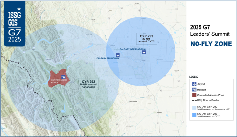
Map of the 2025 G7 Leaders' Summit no-fly zone.
- To ensure the security of the Summit, temporary airspace restrictions will be enforced over the event area during the 2025 G7 Leaders' Summit.
- These temporary restrictions will apply to all unauthorized aircrafts, including drones, within the designated no-fly zone.
- As the lead agency for the 2025 G7 Integrated Security and Safety Group (ISSG), the RCMP will implement a NOTAM (Notice to Airmen) outlining the temporary air restrictions over Calgary and Kananaskis, Alberta, from June 14 at 6 am to June 17 at 11:59 pm local time.
- We are working closely with our aviation partners, including Transport Canada, the Canadian Armed Forces and NAV CANADA, to ensure that these measures are clearly understood and do not unnecessarily impact essential air services.
- There will be two Canadian Restricted Airspace (CYR) structures over the G7 venues:
-
- CYR 292 will be centered on Kananaskis Village (N50°55'22″ W115°08'37″) with a radius of 30 NM (nautical miles), excluding the Calgary/Springbank Airport (CYBW) Control Zone. CYAs 226 and 227 will not be active.
- CYR 293 will be centered on Calgary International Airport (N51°07'21.41″ W114°00'48.05″) with a radius of 20 NM, excluding CYR 292 and including the Calgary/Springbank Airport (CYBW) Control Zone. CYA 228 will not be active.
- We encourage anyone with concerns or questions about airspace restrictions to reach out through our dedicated communication channels.
- Your cooperation with these measures is crucial to maintaining the safety and security of the Summit and surrounding community.
- Date modified: